
 English
 العربية
- Home

- Committee Work
- Quality Assurance
- Shop
- Services
- Wind Resource and Energy Yield Assessment
- Wind Measurement System Configuration
- Meso-Scale Wind Maps
- Micro-Scale Wind Maps
- Power Curve Measurements and Power Performance Verification
- Site Calibration
- Design and Efficiency Optimisation, Component Development and Guidance for Small Wind Turbine Certification
- Site Prospection, Spatial Analyses and Site Selection
- Site classification, Turbulence Intensity Assessment and Extreme Wind Speed Analyses
- Uncertainty Assessments of Wind Resource and Energy Yield
- Assessment of Losses
- V.Mac - for Instant, Remote data Monitoring, Supervision, Evaluation and Control
- Alternating Masts Change Location every 3-4 Months
- Modelling and Validating Simulations of Electrical Characteristics of Power Generators and Systems
- Virtual Measurement Mast
- Hardware
Products
- V.Mac Log-in
- References
- Calibration Services
- Career
- Gallery
- How to find us
- Glossary
- Download Service Brochure
- Accredited Scope
- Flexible Scope
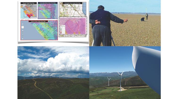
Site Prospection, Spatial Analyses and Site Selection
Increased efficiency on time and budget during on site selection and reduced risks to start development of a wind energy project at a sub-optimal site
Based on remote sensing data we find best sites for your wind farm project!
Spatial analysis is done as first step of any wind farm project planning. Having explored site finding and prospecting activities all over the world, our staff yields highest accuracy as well as time and budget efficiency during site finding, prospection and selection.
We rely on most recent and accurate remote sensing databases, wind resource reanalysis data, topographical, geographical and infrastructure data (i.e. geo-databases). Wind farm developers, investors project initiators, multi-national organizations and local, regional or national governments typically have a need to locate most suitable wind park sites and areas for very different purposes. May it be for project development or for steering and control of regional wind turbine distribution, national energy matrix and power generation portfolio design.
Our efficiency for your budget
Superior objective of our site prospection activities is the quick and immediate localisation of promising areas with high wind resource potential, good infrastructure in the vicinity and low potential for environmental and social conflicts. Starting with the drawing board in an office environment, we could save in a green field project 40%-50% of time and costs until a promising site is localized, visited and finally selected, based on our optimized approaches, which are based on different data sources combined within an in-house developed GIS steering and planning software solution.
Used for individual project site selection and for regional as well as national wind energy planning by government authorities
Site prospection often is time consuming. Even more fatal it would be in terms of time and costs to select a site that is supposed to be good, establish a wind measurement system and discovering at a later point that in fact the site is not suitable in terms of the available wind resource.
ProfEC Ventus for that purpose does elaborate GIS-based results that allow application of queries and filters in order to locate most suitable wind farm sites. As filter criteria could be chosen (exemplary only):
- Proximity to high voltage electricity grid (for example less than 30km),
- Wind speed (of for example ≥ 7.6m/s at 50m h.a.g.l.),
- Distance to an asphalted or gravel compacted street (e.g. not further than 20 km),
- Avoiding environmental protected area nearby,
- Surface roughness length (for example < 0.4m).
Based on such query our GIS tool would highlight as a result all potential sites that are complying with these filtering criteria. Any data in common GIS format could be incorporated and considered in the GIS tool and hence in the query as well. Of course our Clients can incorporate the results into their own, customized database or software applications.
By doing so they safe time, safe efforts, yield better results, reduce the risk of selecting improper or unsuitable sites and avoid environmental or social conflicts when looking at potential sites or regions for wind farm development and planning.
On top we do offer configuration and delivery of potent GIS application and solution, built upon open source GIS software that is free of licensing costs. Latter saves our Client procurement of costly GIS software licenses. Our GIS software solution comes gratis with a collection of different, most recent and high-resolution geodata and online access to remote sensed geo-databases for regular, automated actualisations.
Share, Print and Contact


Accredited Compliance


closer, committed, competitive
Privacy statement Terms and Conditions Legal Copyright © ProfEC Ventus GmbH.2014. All rights reserved.