
 English
 العربية
- Home

- Committee Work
- Quality Assurance
- Shop
- Services
- Wind Resource and Energy Yield Assessment
- Wind Measurement System Configuration
- Meso-Scale Wind Maps
- Micro-Scale Wind Maps
- Power Curve Measurements and Power Performance Verification
- Site Calibration
- Design and Efficiency Optimisation, Component Development and Guidance for Small Wind Turbine Certification
- Site Prospection, Spatial Analyses and Site Selection
- Site classification, Turbulence Intensity Assessment and Extreme Wind Speed Analyses
- Uncertainty Assessments of Wind Resource and Energy Yield
- Assessment of Losses
- V.Mac - for Instant, Remote data Monitoring, Supervision, Evaluation and Control
- Alternating Masts Change Location every 3-4 Months
- Modelling and Validating Simulations of Electrical Characteristics of Power Generators and Systems
- Virtual Measurement Mast
- Hardware
Products
- V.Mac Log-in
- References
- Calibration Services
- Career
- Gallery
- How to find us
- Glossary
- Download Service Brochure
- Accredited Scope
- Flexible Scope
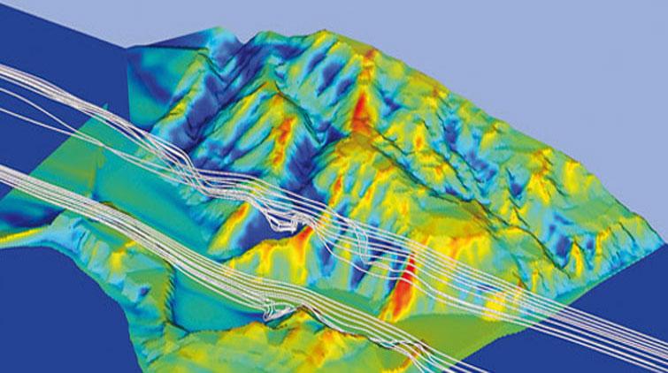
Micro-Scale Wind Maps
Accredited following IEC 17025:2005 as testing laboratory for wind resource assessments, energy yield prognoses and energy yield optimization based on micro-scale wind maps
Wind maps offer special value during project planning, site assessments, energy yields and optimization of energy generation during wind farm planning
For an energetically optimized selection of precise wind turbine positions and wind farm constellation, same as to compare different wind energy projects, micro-scale wind maps are the tool of choice to yield highest possible energy generation at lowest possible infrastructure costs. The wind maps are calculated based on high-resolution digitized topographical information in combination with wind measurement data. The wind measurement database thereby is, followed by the processing flow-model, the determining factor for the accuracy of the resulting wind map. The wind data can either be measured (used for concrete and bankable project development) or derived on re-analysis data, preferably in combination with a meso-scale downscaling CFD application (used for prefeasibility, preliminary project preparation and site preposition phase) like OpenFoam.
The final micro-siting model used at ProfEC Ventus in most cases is the Wind Analysis and Application Software Program (WASP and WASP Engineering) as worldwide acknowledged micro-scale wind atlas calculation method with low uncertainties, accepted by virtually all banks and utilities for high resolution wind energy yield prognoses. Though, we rely on OpenFoam in case of semi-complex and complex terrain as an alternative option.
Both mico-siting models are also of high value in case of analyses and corrective actions to be taken during optimization of an operating wind farm, which is of crucial essence if a wind farm in operation does not reach the expected energy yield prognosis results.
Often wind maps are misinterpreted or erroneously calculated, being based on wrong model assumptions and pretending too optimistic accuracy levels
For purposes of site selection (may it be on municipal, administrative level to appoint planning areas or for the concrete development of a wind farm project at a specific site), the criteria and the requirements associated with a micro-scale wind map should be very precise and accurate. Wind maps dedicated to such purpose should be generated by aid of micro-scale models that do precisely incorporate and respect the local topography and resolution of input wind data. Utilization of unsuitable models lead to erroneous results.
The wind map, once generated, should be verified in order to derive the level of uncertainty attached to the result. Knowing the level of uncertainty helps to avoid misinterpreting the wind map.
Only selection of an appropriate model for individual situations yields in more accuracy and higher energy generation
During wind farm planning and development, sufficient resources should be used to optimize the wind farm design right at the beginning. Appropriate energy yield optimization starts with optimized wind turbine positions in relation to the wind resource probability distribution and wind rose, topography and wind turbine characteristics. Micro-scale wind maps are optimal tools to localize most promising wind turbine spots and to yield an optimized level of energy generation.
Validation of the used model and determination of uncertainties attached to the results are essential for further interpretation, use of results and are part of our daily work.
Share, Print and Contact


Accredited Compliance


closer, committed, competitive
Privacy statement Terms and Conditions Legal Copyright © ProfEC Ventus GmbH.2014. All rights reserved.