
 English
 العربية
- Home

- Committee Work
- Quality Assurance
- Shop
- Services
- Wind Resource and Energy Yield Assessment
- Wind Measurement System Configuration
- Meso-Scale Wind Maps
- Micro-Scale Wind Maps
- Power Curve Measurements and Power Performance Verification
- Site Calibration
- Design and Efficiency Optimisation, Component Development and Guidance for Small Wind Turbine Certification
- Site Prospection, Spatial Analyses and Site Selection
- Site classification, Turbulence Intensity Assessment and Extreme Wind Speed Analyses
- Uncertainty Assessments of Wind Resource and Energy Yield
- Assessment of Losses
- V.Mac - for Instant, Remote data Monitoring, Supervision, Evaluation and Control
- Alternating Masts Change Location every 3-4 Months
- Modelling and Validating Simulations of Electrical Characteristics of Power Generators and Systems
- Virtual Measurement Mast
- Hardware
Products
- V.Mac Log-in
- References
- Calibration Services
- Career
- Gallery
- How to find us
- Glossary
- Download Service Brochure
- Accredited Scope
- Flexible Scope
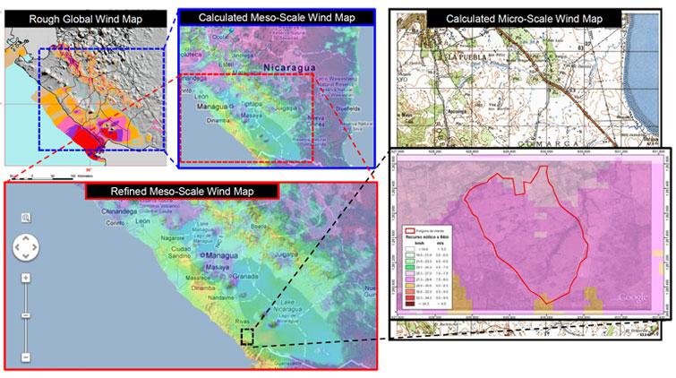
Meso-Scale Wind Maps
A set of modern geo-data used for project site prospection, regulatory spatial development and infrastructure planning; incl. gratis GIS software solutions
Wind maps offer special value for regional spatial planning and for concrete project development
Wind maps have been proven as helpful tool during site prospection and mainly served during first investigations and rough estimate of regional prevailing wind resource potentials.
For an energetically optimal selection of areas for large-scale wind energy development, meso-scale wind maps are the preferred tools of choice to yield a most efficient selection process possible, at lowest possible project development costs.
Meso-Scale wind maps do reflect in relative terms but with an acceptable degree of certainty any sites promising higher wind resource and any sites bearing lower wind resource potentials. Such interpretation and statements remain valid with a high certainty within the comparative context of a meso-scale wind map.
Of crucial essence is an appropriate flow model fitting to the corresponding scale
The criteria and requirements attached to a wind map must be narrow for selection of preferred areas on governmental level, enabling decision makers to appoint areas for prioritized wind farm planning. The majority of wind resource raster calculated nowadays is based on high-resolution digitized topographical information in combination with long-term reanalysis data, reflecting the state of the atmosphere and feeding the models. The wind database is, next to the used flow-model, the determining factor for the resulting accuracy of the wind map calculation.
The models used by ProfEC Ventus experts are based on the Weather Research and Forecast Model (WRF) and OpenFoam (CFD - Computational Fluid Dynamics). The first one for the coarse resolution wind mapping, the second one for the downscaling process to derive wind maps of higher spatial resolution, which take into account micro-scale effects.
By that we rely on wind atlas calculation methods for high resolution wind resource map computing, accepted by project developers, banks and energy regulators.
Important to mention however is that for an individual wind farm project development, the informative value of a meso-scale wind maps often can be interpreted as a good indication only that may run behind the expectations of such wind map. That even more becomes true if a meso-scale wind map (e.g. 5 km x 5 km) is downscaled to micro-scale (resolution of 200m and less), without the use of an appropriate CDF or 3-dimensional flow model.
Based on surface-near measurement data we perform validation of wind maps rather than merely calibration. The latter is an approach, which makes the map fitting to the measurements, but does not offer the possibility to assess the level of uncertainty implicit. It also impedes improvement of the accuracy by being limited to a few measurement spots only, to which the map was calibrated. Validation of wind maps however enables an assessment of the accuracy uncertainty for the wind map.
During our experts’ participation in the development of diverse international programmes (e.g. World Bank and UNDP) for national meso-scale wind mapping, we contributed our unique experience and extensive knowledge to develop wind maps on regional and national level at very diverse parts of the world.
More than just the wind map: a set of modern geo-data used for spatial development and infrastructure planning
Usually our wind maps generated are provided in form of common GIS formats so our Client can incorporate the results into their database or software applications.
We also offer the entire integration of wind maps into our in-house developed GIS steering and development tool. The information can be hosted either online on a server to enable distributed data access, as well as local on the local computers of our Clients. The tool enables spatial analyses and queries, allowing very efficient site prospection activities and conclusion drawing. On top we do offer complete configuration and delivery of a potent, open source GIS application and solution that is free of licensing costs. Our offered GIS software solution comes gratis with a collection of different, most recent geo data and online access to remote sensed geo-databases.
Share, Print and Contact


Accredited Compliance


closer, committed, competitive
Privacy statement Terms and Conditions Legal Copyright © ProfEC Ventus GmbH.2014. All rights reserved.